Saturday, June 30, 2012
Thursday, June 28, 2012
Today's Weather - June 29, 2012
Today we have a chance of rain and thunder in the morning with sunshine by the afternoon. Temps will be in the 80s.
Wednesday, June 27, 2012
Today's Weather - June 28, 2012
Today we will see partly sunny skies and it will be warmer with temps in the mid 70s to low 80s.
Tuesday, June 26, 2012
Today's Weather - June 27, 2012
Today we will see cloudy skies with showers likely. Temps will be in the 60s.
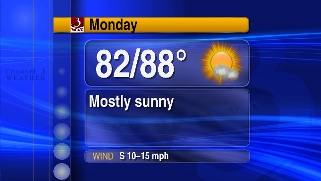
Monday, June 25, 2012
Today's Weather - June 26, 2012
Today we will see cloudy and cool conditions. We will see cloudy skies in the morning with a chance of showers and thunderstorms in the afternoon. Temps will be in the mid 60s.
Sunday, June 24, 2012
Tropical Storm Debby - Update


Today's Weather - June 25, 2012
Today we will see mostly cloudy skies with showers and thunderstorms in the afternoon. It will be cooler with temps in the mid 60s to low 70s
Tropical Storm Debby - Update


Today's Weather - June 24, 2012

Saturday, June 23, 2012
Breaking News: Tropical Storm Debby Forms


Today's Weather - June 23, 2012

Thursday, June 21, 2012
Today's Weather - June 22, 2012
Today we will see partly sunny skies with a chance of thunderstorms in the afternoon. Temps will be in the 80s.
Wednesday, June 20, 2012
HEAT ADVISORY

THE NATIONAL WEATHER SERVICE IN BURLINGTON CONTINUES THE HEAT ADVISORY... UNTIL 8 PM EDT THIS EVENING.
* LOCATIONS... THE CHAMPLAIN VALLEY OF VERMONT AND NEW YORK... WESTERN RUTLAND COUNTY... AND THE SAINT LAWRENCE VALLEY.
* HAZARDS... HOT TEMPERATURES AND HIGH HUMIDITY.
* HEAT INDEX VALUES... UP TO 104 DUE TO TEMPERATURES IN THE LOWER 90S... AND DEWPOINTS AROUND 70.
* TIMING... MAXIMUM TEMPERATURES AND DEWPOINTS WILL CONTINUE THROUGH THE NEXT COUPLE OF HOURS... BEFORE SLOWLY LOWERING THIS EVENING.
* IMPACTS... THE COMBINATION OF HOT TEMPERATURES AND HIGH HUMIDITY WILL COMBINE TO CREATE A SITUATION WHERE PROLONGED EXPOSURE TO THE HEAT CAN CAUSE SERIOUS HEALTH PROBLEMS.
PRECAUTIONARY/PREPAREDNESS ACTIONS...
DRINK PLENTY OF FLUIDS... STAY IN AN AIR-CONDITIONED ROOM... STAY OUT OF THE SUN... AND CHECK IN ON RELATIVES... NEIGHBORS... AND PETS.
TAKE EXTRA PRECAUTIONS IF YOU WORK OR SPEND TIME OUTSIDE. WHEN POSSIBLE... RESCHEDULE STRENUOUS ACTIVITIES TO EARLY MORNING OR EVENING. KNOW THE SIGNS AND SYMPTOMS OF HEAT EXHAUSTION AND HEAT STROKE. WEAR LIGHT WEIGHT AND LOOSE FITTING CLOTHING WHEN POSSIBLE AND DRINK PLENTY OF WATER.
TO REDUCE RISK DURING OUTDOOR WORK... THE OCCUPATIONAL SAFETY AND HEALTH ADMINISTRATION RECOMMENDS SCHEDULING FREQUENT REST BREAKS IN SHADED OR AIR CONDITIONED ENVIRONMENTS. ANYONE OVERCOME BY HEAT SHOULD BE MOVED TO A COOL AND SHADED LOCATION. HEAT STROKE IS AN EMERGENCY - CALL 9 1 1.
Today's Weather - June 21, 2012

Tuesday, June 19, 2012
Today's Weather - June 20, 2012

Monday, June 18, 2012
Today's Weather - June 19, 2012
Today we will see partly sunny skies with a chance of showers in the afternoon. It will be more humid and warmer with temperatures in the 80s.
Sunday, June 17, 2012
Today's Weather - June 18, 2012
Today we will see partly sunny skies and it will be warm with temperatures in the high 70s to low 80s.
Today's Weather - June 17, 2012

Saturday, June 16, 2012
Today's Weather - June 16, 2012

Friday, June 15, 2012

Thursday, June 14, 2012
Today's Weather - June 14, 2012

Wednesday, June 13, 2012
Today's Weather - June 13, 2012

Tuesday, June 12, 2012
Today's Weather - June 12, 2012

Monday, June 11, 2012
Sunday, June 10, 2012
Today's Weather - June 10, 2012

Saturday, June 9, 2012
Today's Weather - June 9, 2012
Today we will see partly cloudy skies this morning with a chance of rain this afternoon. Temps will be in the high 60s to mid 70s.
Friday, June 8, 2012
SEVERE THUNDERSTORM WARNING

INSTRUCTIONS: Get to safety immediately when threatening weather approaches. Winds may knock down trees and power line and damage buildings. Large hail may cause damage to property and cause injury.
Today's Weather - June 8, 2012

Thursday, June 7, 2012
Today's Weather - June 7, 2012

Wednesday, June 6, 2012
Today's Weather - June 6, 2012
Today we will see cloudy skies with a chance of rain throughout the day. Temps will be near 70.
Tuesday, June 5, 2012
Today's Weather - June 5, 2012

Monday, June 4, 2012
Hurricane Season - June 2012
Hurricane Season 2012 has offically started. We did see two named storms in April, which is way early than usual. June is here and some people may be wondering, What is a typical June? Click on the link below to find out: http://www.weather.com/news/weather-hurricanes/june-hurricane-season-20120529
Today's Weather - June 4, 2012

Sunday, June 3, 2012
Today's Weather - June 3, 2012
Today we will see partly cloudy skies this morning with a chance of rain and thunder this afternoon. Temperatures will be in the mid 60's to low 70's.
Saturday, June 2, 2012
Today's Weather - June 2, 2012

Friday, June 1, 2012
WIND ADVISORY

*Hazards: Strong gusty winds
*Winds: Southeast 20 to 30 mph with gusts up 50mph.
*Timing: Strong winds will develop by midnight and continue through mid-morning Saturday.
*Impacts: Trees and power lines can be knocked down under these conditions. In addition, power outages may result.
*Instructions: A WIND ADVISORY means that winds of 35mph or more are expected. Winds this strong can make driving difficult, especially for high profile vehicles. Please use extra caution.
Target Area:
Eastern Addison
Eastern Chittenden
Eastern Franklin
Eastern Rutland
Today's Weather - June 1, 2012

Subscribe to:
Comments (Atom)